
We use cookies to ensure our website works properly and to personalise your experience. Cookies policy
1Centre for Geodesy and Geodynamics (NASRDA), Toro, Bauchi State
2Department of Applied Geology, Tafawa Balewa University, Bauchi, Bauchi State,
3National Space Research and Development Agency – Nigeria
This study examines the significant environmental impacts of tin and associated mineral mining, focusing on the effects on people, soil, and water. Nigeria, abundant in diverse mineral resources across nearly all states, has faced numerous negative reports of illegal mining activities. If not properly monitored and managed, these activities can lead to severe physical, biological, hydrological, and environmental problems. The research aims to assess the impacts of tin mining activities, with the objectives; understanding the physical environmental problems, understanding people's perceptions of mining-related health impacts; and identifying and analysing the potential adverse effects of mining. The methodology involves field surveys of both mining sites and communities, assessment of environmental issues through focus group discussions (FGD), Questionnaires (200) and direct interviews. Data visualization was achieved using Microsoft Excel and ArcGIS 10.7.1, social package statistical software (SPSS 22). The results from the descriptive analysis show a comparison between variables and identify health assessment as the dependent variable. Predictors include gender, age, occupation, community perception of mining, and adverse impacts. Results indicate significant effects of some predictors, leading to the rejection of the null hypothesis (H?), tables and graph were designed to compare quantities across different categories. The second category of survey analysis highlighted the main problems recorded as respiratory tract infections (RTI) and skin infections (SI) caused by mining activities. The study concludes by calling for further research on more environmental parameters and emphasizing the need for proactive measures and enforcement of environmental standards in mining communities, based on the research recommendations.
The digital circuit industry is in a state of rapid evolution, driven by the escalating density and intricacy of digital integrated circuits at deep nanometer dimensions.
Although mining is considered a vital economic activity worldwide, it has a profound negative impact on the environment. Particularly, opencast mining causes significant degradation to the ecological and aesthetic values of the landscape. Parameters commonly affected by such mining activities include topography and drainage, air, soil, and water quality, vegetation (including forest ecosystems), noise levels, ground vibrations, human health, and habitation. Once the extraction of resources is complete, it is essential to reclaim the altered landscape to mitigate the damaging effects of opencast mining and restore the environment and its immediate surroundings (Nazan Kuter,2013).
Tin mining in Plateau State began in the 18th century, long before the arrival of Europeans. Initially, the exploration was conducted locally and marketed through Arab caravans. In the 19th century, the industry gained prominence with the arrival of the British in the area. During this period, Plateau State was part of the ancient Bauchi Province in Northern Nigeria (Cinjel, 2010). As tin mining began earlier in Plateau state, a period of erosion followed the formation of the Younger Granites, resulting in the formation of the major morphological units of the Jos Plateau and the surrounding Kaduna-Bauchi plains. Alluvium deposited by the Plateau Rivers was covered in early Tertiary times by the extensive lava flows of the Older Basalts. The basalts have largely decomposed to clays capped by laterite and dissected by subsequent erosion. Later deposits of alluvium are the source of most of Nigeria's cassiterite production, a further volcanic episode provided the well-preserved cones and the lava flows of the Newer Basalts. It is known that almost all tin production on the Plateau is derived from alluvial concentration shed from the Younger Granites. However, some are also mined from pegmatites. (Macleod, Turner, & Wright, 1971).
Before oil exploration began in Nigeria, the country's economy was primarily sustained by mining and agricultural produce. Unfortunately, the inhabitants of these areas are now facing severe consequences (Oladeji, 2010). Environmental threats such as numerous ponds, devastated agricultural land, and ongoing conflicts over land ownership and elective positions are evident (Plateau State Peace Group, 2014).
Tin mining, particularly in regions like Jos-Plateau, Nigeria, has caused significant environmental damage. The search for cassiterite often leads to the destruction of pastoral lands used for grazing. Additionally, mine dumps and tailings contain radioactive waste, posing serious health risks. Mine ponds have resulted in several fatalities and are sources of environmental contamination. Radioactive minerals released during mining contribute to both environmental and health hazards. Soil degradation and erosion from mining activities lead to the loss of soil nutrients and organic matter, negatively impacting agriculture. Before the 1946 Mining Law, there were no regulations for mineral extraction, processing, and reclamation, resulting in unmitigated environmental damage. Even after the enactment of the law, environmental protections remain insufficient (Chindo, 2012).
LITERATURE REVIEW
Review of some literatures on earlier studies on the environmental implications of mining activities.
Gyang and Ashano (2010) conducted an assessment of the effects of mining on water quality in various areas of the Jos Plateau. They concluded that tin mining does not significantly impact water quality in the region, utilizing geosciences for sustainable development.
Musa and Jiya (2011) evaluated the impact of mining activities on vegetation in the Jos Plateau using the Normalized Differential Vegetation Index (NDVI). They concluded that tin mining significantly disrupted the natural ecology of the study area, stripping organisms and plants of their natural habitats.
Ndace and Danladi (2012) evaluated the biophysical impacts of tin mining activities in Jos using time series analysis of Landsat images. They concluded that mining has significantly disrupted the natural ecology. Consequently, they recommended that mining sites should be regularly monitored, environmental damages should be assessed, mitigation studies should be conducted, and frequent inspections should be implemented to control these activities.
Michael Ajide Oyinloye (2015) research utilized IKONOS imagery within Geographical Information Systems (GIS) to buffer and extract buildings within a 3km radius of a mining site. The results indicated that most buildings within this buffer zone are at high risk, facing issues such as air pollution, noise pollution, and associated health effects.
Princewill C. Ogbonna and colleagues, 2015 conducted an integrated approach utilizing well-structured questionnaires and personal observations within the study area was employed. The study identified blindness as the primary health hazard resulting from mining activities. Notably, coal mining had a detrimental impact on several socio-economic activities of the residents in the mined area. This negative effect was primarily due to the removal of vegetation to access coal deposits, as well as the processes of blasting, quarrying, and crushing coal.
Adeyinka O. Omotehinse's 2019 research encompasses a field survey, direct mapping of mining activities, assessment of the impacts of exploration and exploitation, documentary analysis, and observations. The study's results provide an analysis of the environmental impacts of tin and coal mining.
According to Oruonye and Ahmed (2017), despite conducting field surveys and discussions addressing the challenges from abandoned mine sites, the local communities did not report any unusual illnesses or effects related to the mining activities. Many residents even rely on water from the abandoned uranium mine pit for domestic use. The study recommends periodic monitoring of water and agricultural crops to determine any potential radioactivity effects associated with the uranium ore deposits. Additionally, it suggests educating the local communities about the potential impacts of the abandoned uranium mines on their land, soil, air, and water.
PROBLEM STATEMENT
One of the primary motivations for this study is the connection between the challenges faced by the populace and the environmental issues resulting from mining activities. The study area encompasses both small-scale (artisanal) and large-scale mining operations, which pose significant environmental risks, including the uncontrolled release of heavy metals (toxicity), soil erosion, land degradation, and other human impacts. To address these issues, this research adopts a comprehensive methodology that integrates geological investigation, FGDs and survey studies to assess the environmental impacts of tin mining, and applies subsequent techniques to mitigate these challenges. The cumulative effects on the immediate local environment have been profound, with far-reaching consequences that may threaten the very existence of life.
Aim and Objectives
The aim of the research is to assess the impacts of tin mining on the environment.
these can be achieved via the following objectives:
STUDY AREA DESCRIPTION
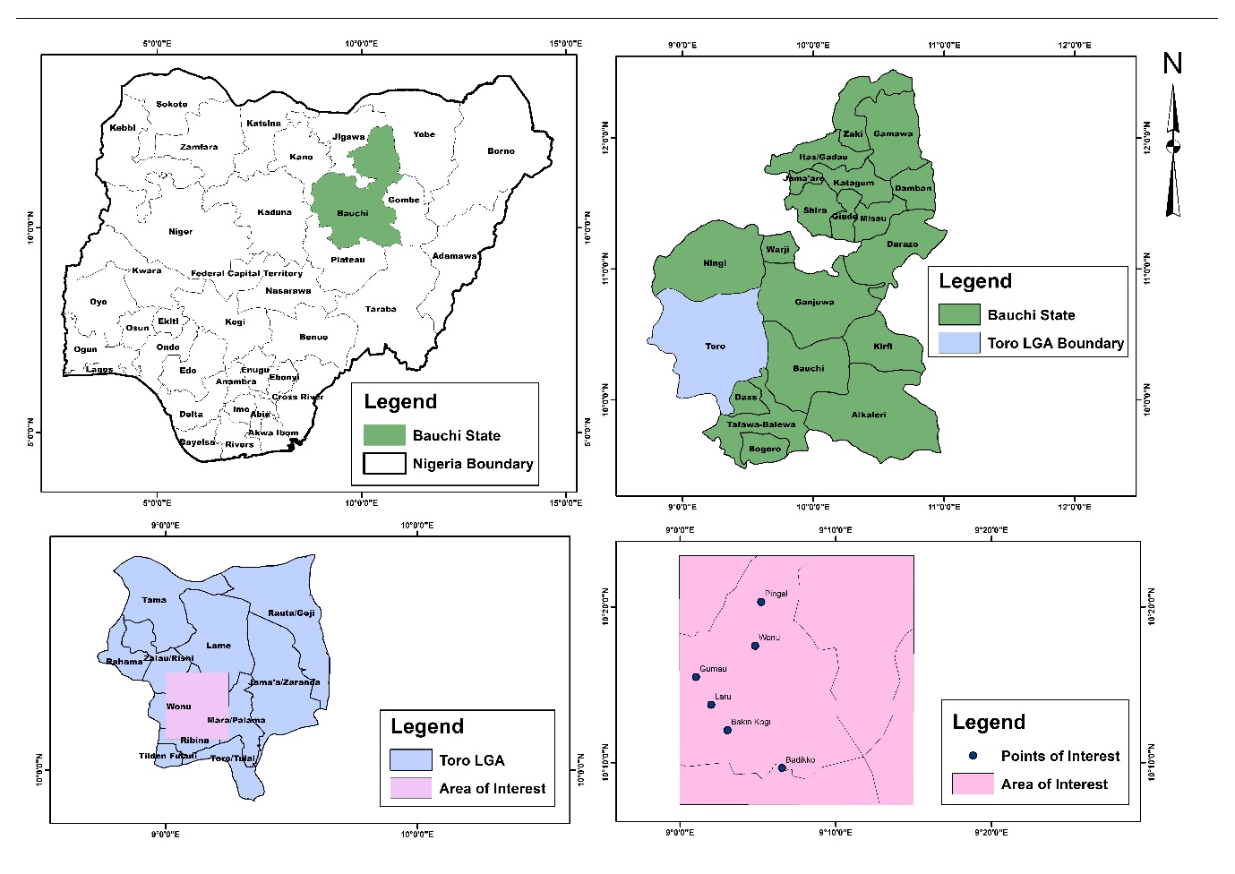
Pingel and its surroundings fall within the southern part of Toro Local Government Area Bauchi State, Nigeria. Its one of the twenty LGAs in the state. The area is located between Latitudes 10?19′43.85″N and 10?15′54.0″N and Longitudes 9?5′32.26″E and 9?08′00.3″E (Figure 1). The study area covers about 54 square kilometres and has various topographic landscapes, including spurs, saddles, valleys, and river channels features.
The vegetation in the study area varies between the dry and wet seasons. The average annual temperature is approximately 29.87°C, with temperatures ranging from about 13.9°C (57°F) during cooler periods to 39.2°C (102.6°F) during the hottest months. Humidity levels in Toro can vary significantly, dropping to as low as 19% during the dry season and rising to as high as 78% in the wet season (Weather Forecast, 2024).
GEOLOGY OF THE AREA
Pingel and its surrounding communities falls closely to Saiya-Shokobo complex, approximately 48km north of Jos (Aga. T and Haruna A.I 2019). This area forms an extensive and prominent hill mass, isolated from the main body of the Plateau. The complex creates a northern-trending ellipse, contiguous with the Jere-Sanga complex. At the northern end, a narrow arm extends through the Rishi Neil hills to the east, joining the northern end of the Tongolo complex. The total area of Younger Granite rocks is 97 square miles (Bulletin 32 Vol.1). The watershed lies near the eastern margin, locally known as the Delimi River. Principal streams flow northwest in deeply incised valleys, their alignment controlled by the predominant joint direction, as most of the area is underlain by rhyolites and porphyries, which form boulders.
Major rock types in the area include Migmatite Gneiss, Pegmatite, Trachyte, Granulitic Granite, and Biotite Gneiss and all representative of older and younger granites. These Pan-African rocks from the Palaeozoic, Mesozoic, and Cenozoic eras have undergone tectonic activities resulting in fracturing, jointing, and cracking (Rahaman, 1988; Oyawoye, 1970).
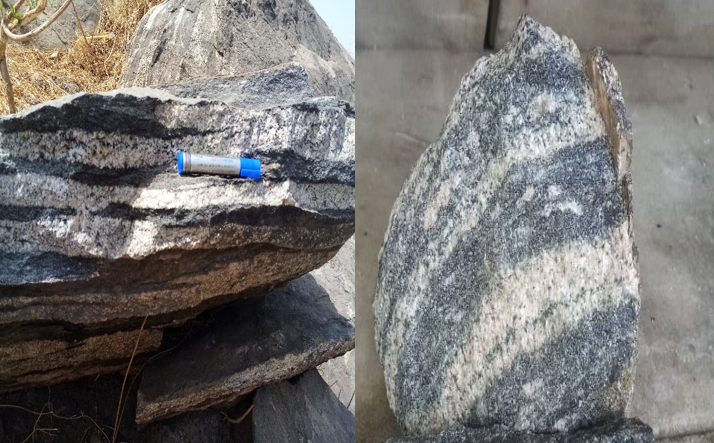
PLATE 1: Field observation and hand specimen showing Banded Gneiss (Badikko)
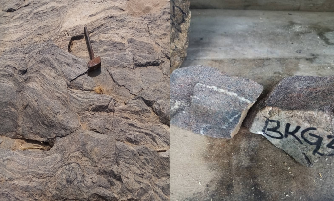
PLATE 2: Field observation and hand specimen showing Migmatite Gneiss (Bakin Kogi).
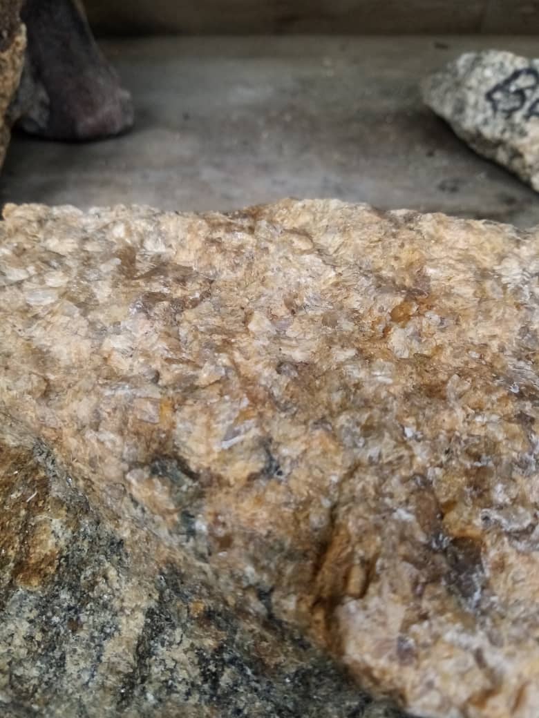
PLATE 3: Hand specimen showing Pegmatite (Gumau)

PLATE 4: Hand specimen showing Granite (Feldspathoid) Pingel
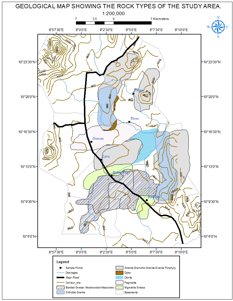
Fig1: Geological Map of the Study Area.
METHODOLOGY
The study employed an integrative research approach, the qualitative aspect captures the depth of experiences and perspectives through observations and discussions, while the quantitative side provides statistical validation through survey, analysed with ANOVA. Designing survey research questions to gather information on the environmental challenges of mining at both community and mining levels, Field investigation and observation, focus group discussions (FGDs), a comprehensive questionnaire were administered to 200 respondents, which covered topics such as; the demographic information, community perceptions of mining, health impact, adverse impacts, and suggestions from respondents. A literature review on related subjects was also conducted. During the initial phase of research, which included ground touring and FGD data was collected using handheld GPS devices, cameras, and, survey questionnaires and field note books. The collected data was visualized using Microsoft Excel and then exported to the ArcGIS 10.7.1 environment to produce study area map and geological maps. For further survey analysis, SPSS 22 (Statistical Package for the Social Sciences) software was utilized for descriptive statistics (ANOVA).
RESULTS AND FINDINGS.
The research findings from the field observations and focus group discussions (FGD) identified several issues such as contaminated areas, abandon mine sites as seen and reported by the populace and also people’s interaction on the mining site. Other important impacts observed are erosion and degradation areas (plate 5, 6,7 and 8) which necessitate for the survey analysis.
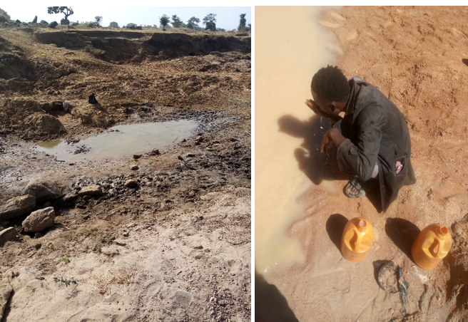
PLATE 5: Abandon mine site and how people consume water for domestic use.
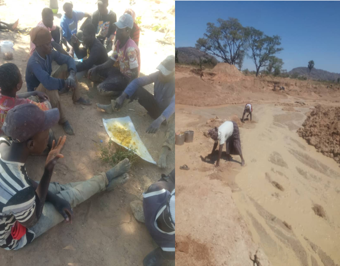
PLATE 6: Peoples interactions after work(L) and some women at work(R)
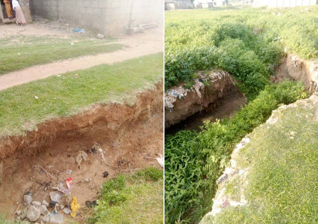
PLATE 7: Showing some environmental problems observed in areas close to mining sites. (Gumau).
Results from the survey analysis indicates the age structure and gender group of the respondents in table 1 below;
|
Descriptive Statistics |
||||
|
Dependent Variable: Health impact |
||||
|
Gender of the respondents |
Ages of the respondents |
Mean |
Std. Deviation |
N |
|
Male |
1- 25 years |
2.21 |
.917 |
78 |
|
26 years and above |
1.79 |
.695 |
96 |
|
|
Total |
1.98 |
.826 |
174 |
|
|
Female |
15-25 years |
2.27 |
.458 |
15 |
|
26 years and above |
3.00 |
.000 |
11 |
|
|
Total |
2.58 |
.504 |
26 |
|
|
Total |
15-25 years |
2.22 |
.858 |
93 |
|
26 years and above |
1.92 |
.754 |
107 |
|
|
Total |
2.05 |
.816 |
200 |
|
Table 1: showing the gender and the age structure of the respondents
The table for the descriptive statistics shows that there are 174 male respondents and 26 female all in 200 responds. And for the age group it is structured for 15 – 25 years and 26 years and above. About 78 respondents are within the ages of 15 -25 years and 96 male respondents are within age of 26 years and above; 15 female respondents are within the ages of 15 – 25 years and 11 female respondents are within the age of 26 years and above respectively.
Other tables below shows the general status of all the variables used for the analysis, which will help in correlating each variable to understand the strength of relationship i.e. how strong each two variables are related, the direction of the relationship either negative or positive correlation, pattern of relationship which will help in identifying and predicting the impacts, and also help to understand how a variable affect the other leading to further investigation to determine if one variable actually causes changes in the other.
|
Levene's Test of Equality of Error Variancesa |
|||
|
Dependent Variable: Health impact |
|||
|
F |
df1 |
df2 |
Sig. |
|
29.423 |
17 |
182 |
.000 |
|
Tests the null hypothesis that the error variance of the dependent variable is equal across groups. |
|||
The table here explains the dependent variable which is health impact against the other predictors. Levene's Test is used to assess the equality of variances for a variable calculated for two or more groups. The F-value in Levene's statistics is a measure used to determine whether the variances are significantly different from each other. Here the F value from Levene's test has 29.423. the F value is a measure used to determine whether the variances are significantly different from each other. A higher F-value typically indicates greater variance between the groups, df1 represents the degrees of freedom for the numerator, which is the number of groups minus one; which stand as 17, df2 represents the degrees of freedom for the denominator which is the total number of observations minus the number of groups, is 182. Sig. (p-value) is the significance level of the test, the results show .000 (which is often written as p < 0.001) and if the p-value is less than the chosen significance level (commonly 0.05), it indicates that there is a statistically significant difference in the variances across the groups.
Tests of Between-Subjects Effects
Dependent Variable: Health impact
|
Source |
Type III Sum of Squares |
Df |
Mean Square |
F |
Sig. |
|
Corrected Model |
110.456a |
17 |
6.497 |
53.902 |
.000 |
|
Intercept |
306.119 |
1 |
306.119 |
2539.531 |
.000 |
|
Gender |
3.255 |
1 |
3.255 |
27.003 |
.000 |
|
Occupation |
2.630 |
2 |
1.315 |
10.908 |
.000 |
|
Perception |
1.548 |
2 |
.774 |
6.423 |
.002 |
|
Impact |
2.058 |
1 |
2.058 |
17.076 |
.000 |
|
Age |
.222 |
1 |
.222 |
1.844 |
.176 |
|
Gender * Occupation |
.000 |
0 |
. |
. |
. |
|
Gender * Perception |
.000 |
0 |
. |
. |
. |
|
Gender * Impact |
.423 |
1 |
.423 |
3.513 |
.062 |
|
Gender * Age |
.229 |
1 |
.229 |
1.896 |
.170 |
|
Occupation * Perception |
1.172 |
1 |
1.172 |
9.719 |
.002 |
|
Occupation * Impact |
.000 |
0 |
. |
. |
. |
|
Occupation * Age |
.475 |
1 |
.475 |
3.940 |
.049 |
|
Perception * Impact |
.000 |
0 |
. |
. |
. |
|
Perception * Age |
.000 |
0 |
. |
. |
. |
|
Impact * Age |
.638 |
1 |
.638 |
5.295 |
.023 |
|
Gender * Occupation * Perception |
.000 |
0 |
. |
. |
. |
|
Gender * Occupation * Impact |
.000 |
0 |
. |
. |
. |
|
Gender * Occupation * Age |
.000 |
0 |
. |
. |
. |
|
Gender * Perception * Impact |
.000 |
0 |
. |
. |
. |
|
Gender * Perception * Age |
.000 |
0 |
. |
. |
. |
|
Gender * Impact * Age |
.000 |
0 |
. |
. |
. |
|
Occupation * Perception * Impact |
.000 |
0 |
. |
. |
. |
|
Occupation * Perception * Age |
.000 |
0 |
. |
. |
. |
|
Occupation * Impact * Age |
.000 |
0 |
. |
. |
. |
|
Perception * Impact * Age |
.000 |
0 |
. |
. |
. |
|
Gender * Occupation * Perception * Impact |
.000 |
0 |
. |
. |
. |
|
Gender * Occupation * Perception * Age |
.000 |
0 |
. |
. |
. |
|
Gender * Occupation * Impact * Age |
.000 |
0 |
. |
. |
. |
|
|
|
|
|
|
|
|
Gender * Perception * Impact * Age |
.000 |
0 |
. |
. |
. |
|
Occupation * Perception * Impact * Age |
.000 |
0 |
. |
. |
. |
|
Gender * Occupation * Perception * Impact * Age |
.000 |
0 |
. |
. |
. |
|
Error |
21.939 |
182 |
.121 |
|
|
|
Total |
977.000 |
200 |
|
|
|
|
Corrected Total |
132.395 |
199 |
|
|
|
|
a. R Squared = .834 (Adjusted R Squared = .819) |
|||||
Interpretation:
Based on the Leven’s test of equality of variance above, for the predictor variables: gender, age, occupation, adverse impact and the community perceptions of the respondents The p-value (Sig.) of .000 is less than 0.05, indicating that the null hypothesis (which states that the error variances are equal across the groups) is rejected. This means there is significant evidence that the variances are not equal across the groups for the dependent variable "Health impact."
TEST BETWEEN SUBJECTS EFFECTS:
Since the hypotheses is for tests between subjects’ effects which are;
- H0: the independent variables have no effect on health impacts.
- H0: there is no significant interactions between the independent variables.
From the result analysis of the above table, interaction does not exist between gender, adverse impact and gender age, because they have a p–value of 0.062 and 0.170 respectively which are above the significant level of 0.05. Again, for the variables gender, occupation, community perception, and adverse impacts having value of 0.000, which are well below the significance level of 0.05, except for age, which has a value of 0.176. Herein, we reject the null hypothesis and conclude that these independent variables significantly impact on the health of the respondents, except for age.
While the interactions between the independent variables of Gender, Community perception and adverse Impact is 0.062, for Gender and age is 0.170, Occupation and Community Perception is 0.002, Occupation and Age is 0.049, Community and age is 0.023 respectively. Therefore; based on these p-values stated we can reject the null hypothesis and conclude that significant interactions exist between some independent variables, specifically in Occupation and Community Perception, Occupation and age and finally, Community and age. However, interactions do not exist between gender and adverse impact and also gender and age, as their p-values are 0.062 and 0.170, respectively, which are above the significance level of 0.05.
Furthermore, the above interpretation has given rise to another evaluation of variables such as occupation and community perception against health impact. This is to clarify the predictor with significant impact on the dependent variable.
The evaluation starts with relationship between occupation and the health impact to understand their strength of their relationship followed by community perceptions which was an important variable against health impact.
MULTIPLE COMPARISON FOR OCCUPATION OF THE RESPONDENTS
|
Multiple Comparism |
|||||||
|
Dependent Variable: Health impact |
|||||||
|
|
(I) Occupation of the respondents |
(J) Occupation of the respondents |
Mean Difference (I-J) |
Std. Error |
Sig. |
95% Confidence Interval |
|
|
Lower Bound |
Upper Bound |
||||||
|
Tukey HSD |
Mining |
Farming |
-1.33* |
.078 |
.000 |
-1.51 |
-1.14 |
|
Mining and Farming |
-1.21* |
.054 |
.000 |
-1.34 |
-1.08 |
||
|
Farming |
Mining |
1.33* |
.078 |
.000 |
1.14 |
1.51 |
|
|
Mining and Farming |
.12 |
.075 |
.266 |
-.06 |
.30 |
||
|
Mining and Farming |
Mining |
1.21* |
.054 |
.000 |
1.08 |
1.34 |
|
|
Farming |
-.12 |
.075 |
.266 |
-.30 |
.06 |
||
|
LSD |
Mining |
Farming |
-1.33* |
.078 |
.000 |
-1.48 |
-1.17 |
|
Mining and Farming |
-1.21* |
.054 |
.000 |
-1.32 |
-1.11 |
||
|
Farming |
Mining |
1.33* |
.078 |
.000 |
1.17 |
1.48 |
|
|
Mining and Farming |
.12 |
.075 |
.120 |
-.03 |
.27 |
||
|
Mining and Farming |
Mining |
1.21* |
.054 |
.000 |
1.11 |
1.32 |
|
|
Farming |
-.12 |
.075 |
.120 |
-.27 |
.03 |
||
|
Based on observed means. The error term is Mean Square (Error) = .121. |
|||||||
|
*. The mean difference is significant at the .05 level. |
|||||||
From the above table of evaluation, the levels of occupation have been observed that, mining, farming and mining (both) have 0.000 values while for farming, mining and farming has value of 0.266 in Tukey and 0.120 in LSD respectively. We can therefore reject the null hypothesis and conclude that a significant mean difference exists between some levels of occupation (i.e. mining + farming, and mining + mining and farming).
For the Tukey HSD (Honestly Significant Difference) Test, for those involved in mining verses those involved in Farming has the mean difference of -1.33, Standard error 0.078, Significant (p-value) 0.000, 95% level of Confidence, (lower and upper boundary) Interval -1.51 to -1.14. Here the mean health impact for respondents in mining is significantly lower than for those in farming, with a mean difference of -1.33, which states that the difference is statistically significant (p < 0.05).
Respondents involved in mining verses those respondents involved in each occupation has the mean value of -1.21, Standard error of 0.054, Significant (p-value) 0.000, 95% level of Confidence Interval -1.34 to -1.08. Here the mean health impact for respondents in mining is significantly lower than for those involved in both mining and farming, with a mean difference of -1.21, which states that the difference is statistically significant (p < 0.05). But in the case of Farming verses both occupation the mean difference is 0.12, Standard error: 0.075, Significant (p-value) 0.266, 95% level of Confidence, Interval -0.06 to 0.30. The difference in mean health impact between respondents in farming and those involved in both mining and farming is not statistically significant (p > 0.05). In essence, the results suggest that the health impacts are notably worse when mining is combined with farming activities, highlighting a potential area of concern for public health interventions.
MULTIPLE COMPARISON FOR COMMUNITY PERCEPTION OF THE RESPONDENTS
The hypothesis for this is:
H0: there is no mean difference between the levels of community perceptions of the respondents
|
Multiple Comparisons |
|||||||
|
Dependent Variable: Health impact |
|||||||
|
|
(I) Community perception of respondents |
(J) Community perception of respondents |
Mean Difference (I-J) |
Std. Error |
Sig. |
95% Confidence Interval |
|
|
|
Lower Bound |
Upper Bound |
|||||
|
Tukey HSD |
Unchanged |
declined |
-1.03* |
.049 |
.000 |
-1.15 |
-.91 |
|
improve |
-.43 |
.248 |
.191 |
-1.02 |
.15 |
||
|
Declined |
unchanged |
1.03* |
.049 |
.000 |
.91 |
1.15 |
|
|
improve |
.60* |
.248 |
.045 |
.01 |
1.18 |
||
|
Improve |
unchanged |
.43 |
.248 |
.191 |
-.15 |
1.02 |
|
|
declined |
-.60* |
.248 |
.045 |
-1.18 |
-.01 |
||
|
LSD |
Unchanged |
declined |
-1.03* |
.049 |
.000 |
-1.13 |
-.93 |
|
improve |
-.43 |
.248 |
.083 |
-.92 |
.06 |
||
|
Declined |
unchanged |
1.03* |
.049 |
.000 |
.93 |
1.13 |
|
|
improve |
.60* |
.248 |
.017 |
.11 |
1.09 |
||
|
Improve |
unchanged |
.43 |
.248 |
.083 |
-.06 |
.92 |
|
|
declined |
-.60* |
.248 |
.017 |
-1.09 |
-.11 |
||
|
Based on observed means. The error term is Mean Square (Error) = .121. |
|||||||
|
*. The mean difference is significant at the .05 level. |
|||||||
From the evaluation table above, Unchanged environment verses Declined environment has a mean difference of -1.03, Standard error of 0.049, significant value 0.000, 95% level of Confidence Interval -1.15 to -0.91. Here the mean health impact for respondents whose community perception is "unchanged" is significantly lower than for those whose perception is "declined," with a mean difference of -1.03, the difference is statistically significant (p < 0.05). the results from respondents with unchanged environment verses those respondents with improve opinion the mean difference is -0.43, Standard error: 0.248, and p-value 0.191, 95% Confidence Interval -1.02 to 0.15. Therefore, the difference in mean health impact between respondents whose community perception is "unchanged" and those whose perception is "improved" is not statistically significant (p > 0.05) in this case. While in the opinion of respondents with declined environment verses those with unchanged environment have a mean difference of 1.03, Standard error: 0.049, Significant (p-value): 0.000, 95% Confidence Interval: 0.91 to 1.15. Therefore, the mean health impact for respondents whose community perception is "declined" is significantly higher than for those whose perception is "unchanged," with a mean difference of 1.03, the difference is statistically significant (p < 0.05).
Never the less, there are statistically significant differences in health impact based on community perception. Specifically, respondents with a "declined" community perception experience higher health impacts compared to those with "unchanged" or "improve" perceptions. The differences between "unchanged" and "improve" perceptions are not statistically significant.
Distribution of Health Impacts by Category.
The hypothesis;
H0: there is no difference between the percentage distributions of diseases.
|
Health impact |
|||||
|
|
Frequency |
Percent |
Valid Percent |
Cumulative Percent |
|
|
Valid |
RTI |
61 |
30.5 |
30.5 |
|
|
Skin Infection |
67 |
33.5 |
64.0 |
||
|
None |
72 |
36.0 |
|||
|
Total |
200 |
100.0 |
100.0 |
100.0 |
|
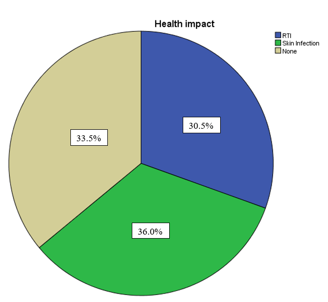
Interpretation
30.5% of respondents reported having RTI, indicating that approximately one-third of the population is affected by this condition. While the most common health issue, with 33.5% of respondents reporting skin infections, highlighting it as the prevalent health problem in the community. 36.0% of respondents reported no disease, making it the largest single category, suggesting that a significant portion of the population is not currently experiencing these health issues. The total number of respondents is 200, with each health condition category summed up to 100%. The cumulative percentage helps to understand the progressive accumulation of respondents in each health category, ending with 100% when all respondents are considered.
Result Implications
The data indicates that skin infections are the predominant health issue in the community, followed by respiratory tract infections. Considering the significant portion of the population affected by these conditions, public health initiatives should focus on addressing the causes and treatments for skin infections and respiratory tract infections. Additionally, the largest segment of the population reports no health problems, which suggests that more than a third of the community is currently healthy, potentially due to environmental adaptation.
DISCUSSION.
The study area encompasses both local small-scale (artisanal) and large-scale mining operations, which pose significant environmental risks, including the uncontrolled release of heavy metals (toxicity), soil erosion, land degradation, and other human impacts. To address these issues, the research considered several objectives as to understanding the physical environmental problems, understanding people's perceptions of mining-related health impacts, Identifying and analysing the potential adverse effects of mining. The study employed a qualitative approach, designing survey research questions to gather information on the environmental challenges of mining at both community and mining levels. A comprehensive study was carried out consisting of focus group discussions (FGDs) and (200) questionnaires were developed to cover topics such as demographic information, community perceptions of mining, health impact, adverse impacts, and environmental suggestions from respondents. Based on field investigation and observations, several issues were identified, such as contaminated areas, abandoned mine sites, and how people consume water directly from the mining areas. Erosion and degradational areas (plates 5, 6, 7, and 8) were also observed. Personal observations from the study noted that houses were washed off by erosion, and farmland was degraded, which was confirmed and reported by respondents as an environmental challenge on the host communities. The long-term implications of such displacement include accelerated food insecurity and intensified environmental degradation, which can endanger the life of people and the mine operators (Kitula 2006).
These necessitated for the survey analysis. Results from survey analysis was based on the hypothesis H0: the independent variables have no effect on health impacts. The hypothesis that there are no significant interactions between the independent variables, was also rejected. Here, Interaction does not exist between gender, adverse impact, and age (p-values of 0.062 and 0.170, respectively, which are above the significance level of 0.05). For the variables gender, occupation, community perception, and adverse impacts with p-values of 0.000, they are well below the significance level of 0.05, except for age, which has a p-value of 0.176. Thus, we reject the null hypothesis and conclude that these independent variables significantly impact the health of the respondents, except for age. Interaction between Gender, Community perception, and adverse Impact: p = 0.062, Gender and age: p = 0.170, Occupation and Community Perception: p = 0.002, Occupation and Age: p = 0.049, Community and age: p = 0.023
Based on these p-values, we can reject the null hypothesis and conclude that significant interactions exist between some independent variables, specifically in Occupation and Community Perception, Occupation and age, and finally, Community and age. However, interactions do not exist between gender and adverse impact and also gender and age, as their p-values are 0.062 and 0.170, respectively, which are above the significance level of 0.05.
Multiple Analysis for Occupation, respondents involved in mining versus those involved in other occupations show a significant mean difference in health impact (mean difference: -1.21, p < 0.05). The difference in mean health impact between respondents in farming and those involved in both mining and farming is not statistically significant (mean difference: 0.12, p > 0.05).
These results suggest that the health impacts are notably worse when mining is combined with farming activities, highlighting a potential area of concern for public health interventions.
Community Perception and Health Impact, analysis reveals that respondents with a 'declined' perception of their environment experience significantly higher health impacts compared to those with an 'unchanged' perception (mean difference: 1.03, p < 0.05). This highlights the potential adverse health effects associated with negative environmental perceptions. Improved perceptions did not significantly alter health outcomes (mean difference: -0.43, p > 0.05).
For disease distribution, evaluation of reported diseases among the populace was based on the hypothesis H0: there is no difference between the percentage distributions of diseases. The analysis revealed a variation in disease distribution among the respondents and the non-infected individuals 30.5% (61 respondents) were infected with respiratory tract infections (RTI). 33.5% (67 respondents) had skin infections and 36.0% (72 respondents) reported no disease respectively.
Therefore, we can reject the null hypothesis, indicating a significant difference exists between the distributions of impacts among the respondents, with skin infections being more prevalent than respiratory tract infections (RTI).
Based on environmental and health Impacts mining activities were observed to have caused a wide range of environmental hazards. From respondents’ perceptions, mining activities resulted in water pollution, followed by the loss of land. For health, 30.5% of respondents recorded respiratory tract infections (RTI), 36.0% recorded skin infections, and 33.5% reported no infections, all resulting from mining activities. Given that most water resources in the mining areas are used for drinking by inhabitants and livestock, pollution of water sources by mining can burden the populace, especially women and children who collect water for household use in rural communities (Kitula 2006).
The present research aligns with Adeyinka O. Omotehinse's 2019 study, emphasizing the necessity for further assessments of mining fields through comprehensive field observations and surveys to achieve accurate research conclusions. This research concurs with the findings of Oruonye and Ahmed (2017), who recommend periodic monitoring of key parameters to detect any potential effects related to the deposits. Additionally, this research agrees with the work of Princewill C. Ogbonna (2015), which identified blindness as the primary health hazard due to mining activities. In contrast, the present study highlights that tin mining primarily resulted in respiratory tract infections (RTI) and skin infections, while other respondents reported no complaints.
CONCLUSION
In conclusion, the study reveals that small-scale and large-scale mining operations pose significant environmental and health risks, primarily due to the uncontrolled release of heavy metals, soil erosion, and land degradation. The integrative approach employed, including field investigation, focus group discussions (FGD) and comprehensive surveys, highlighted several critical issues such as contaminated areas, abandoned mine sites, and direct consumption of water from these sites.
The analysis indicates that independent variables, including gender, occupation, and community perception, significantly impact health outcomes, with mining activities combined with farming showing notably worse health impacts. The study also identifies a strong correlation between negative environmental perceptions and adverse health effects, emphasizing the need for addressing community perceptions in public health strategies.
Health distribution analysis further underscores the prevalence of skin infections over respiratory tract infections among respondents, linking these health issues directly to mining activities. Observations from the field confirm significant environmental degradation, including water pollution and loss of land, exacerbating the vulnerability of rural communities, especially women and children.
The research aligns with previous studies, reinforcing the necessity for periodic monitoring and comprehensive assessments to mitigate the long-term implications of mining activities. These findings underscore the importance of integrating environmental management with public health strategies to safeguard the well-being of communities in mining regions.
Recommendations
Based on reports the following recommendations should be considered;
Ensure that water resources in mining areas are regularly tested and treated to prevent contamination, especially since these water sources are used for drinking by local inhabitants and livestock.
REFERENCES


Mohammed Hauwa Aliyu, Haruna Ahmed Isa, Omega John Unogwu, Umar Sambo, Amobi Yekini, Assessment of The Impacts of Tin Mining Around Pingel, Toro Local Government Area, Bauchi State, Int. J. in Engi. Sci., 2025, Vol 2, Issue 2, 1-17. https://doi.org/10.5281/zenodo.14872951
 10.5281/zenodo.14872951